Data Model
Overview
The DTCC Data Model is designed to represent city-scale objects, their geometries, and associated data values in a consistent and extensible manner. It enables the modeling of physical and virtual city elements—ranging from entire cities and buildings to finer components such as park benches or road networks—while supporting robust spatial analysis and I/O operations.
High-Level Design
The DTCC Data Model is organized into three core categories:
Objects: These represent the physical or virtual entities within a city (e.g., buildings, terrains, road networks). Every object inherits from the common base class
Object, which in turn derives from a broaderModel. All objects have a unique identifier and support hierarchical (parent-children) relationships. Importantly, each object may possess multiple geometrical representations (e.g., different levels of detail).Geometries: Geometries define the spatial representation of objects. Every geometry derives from a common base class
Geometryand comes in various types—ranging from 2D primitives (polygons, linestrings) to 3D representations (meshes, point clouds). Each geometry includes attributes such as bounds, coordinate systems, and affine transforms, enabling robust spatial computations and transformations.Values: Value classes are used to associate data with the geometry of an object. Examples include the
Fieldclass for scalar or vector data and theRasterclass for grid-based imagery. This separation of spatial representation from descriptive or simulation data ensures that the model remains flexible and maintainable.
Key Features
Unique Identifiers & Hierarchical Structure: Every object includes an
idand supports parent-child relationships to naturally represent complex structures (e.g., a city containing buildings, which in turn consist of building parts).Standardized Spatial Handling: Geometries calculate bounds automatically and maintain coordinate system and transformation details, ensuring that local representations can be converted to global coordinates.
Robust Serialization: All core classes implement
to_proto()andfrom_proto()methods, enabling efficient, standardized serialization via Protobuf.Extensibility and Modularity: The use of base classes (
Model,Object,Geometry) ensures that common functionality is inherited by specialized classes, reducing duplication and facilitating consistent behavior across the system.
Examples in the Model
Buildings and Building Parts: A
Buildingobject (inheriting fromObject) can include multipleBuildingPartobjects. Each building or part can have multiple geometries representing various levels of detail, such as a simple footprint (LOD0) or a detailed 3D mesh.City as a Container: The
Cityclass aggregates various objects—buildings, terrain, road networks— managing their spatial relationships and providing helper methods to manipulate or query these elements.Spatial Data Management: The base class
Geometryand its derivatives (e.g.,Mesh,Grid,Surface) automatically calculate bounds, support merging operations, and handle coordinate transformations, which are essential for integrating with external GIS systems.
UML Diagram
Below is an overview of the data model illustrated as a UML diagram. This diagram shows the high-level organization into Objects, Geometries, and Values, and highlights key inheritance relationships.
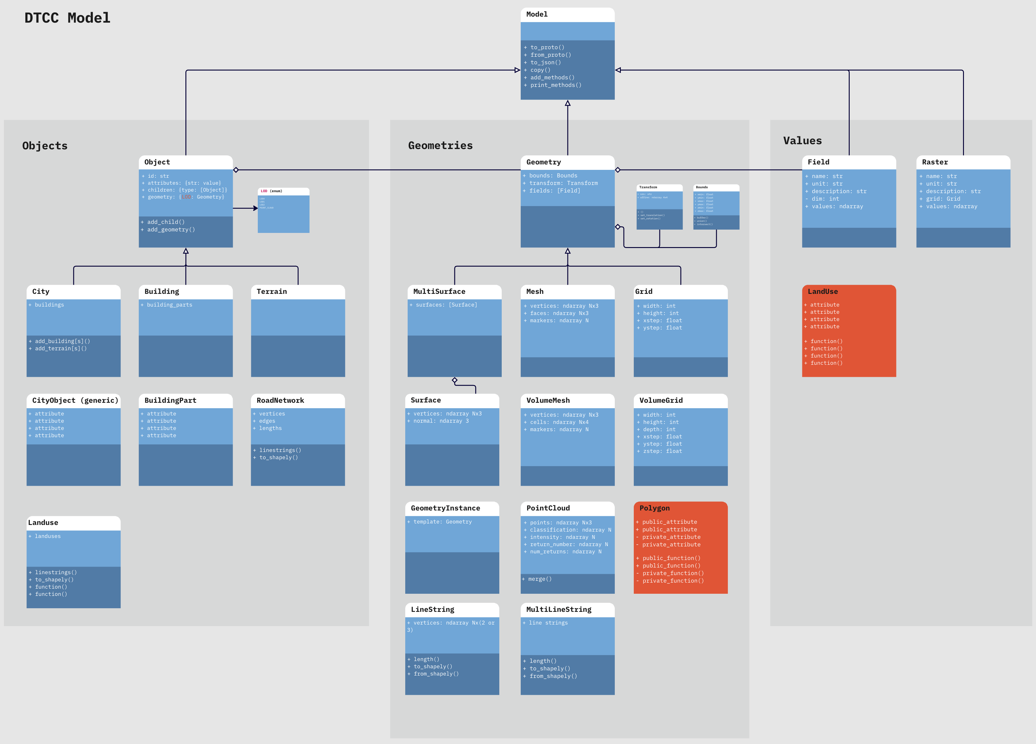
UML diagram of the DTCC Data Model, illustrating the three core categories (Objects, Geometries, and Values) and their interrelationships.
Conclusion
The DTCC Data Model offers a comprehensive and modular framework for city modeling. Its clear separation into Objects, Geometries, and Values provides flexibility and scalability. By leveraging Python dataclasses for clarity and Protobuf for robust I/O, the model supports both detailed local analyses and broad interoperability with external systems.
For more detailed documentation, please refer to the generated API reference pages.